Smithfield comprehensive plan headed to Town Council with planners’ blessing
Published 5:05 pm Wednesday, June 15, 2022

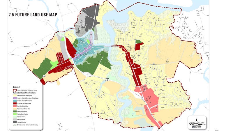
- The future land use map in Smithfield's 2022 comprehensive plan shows some areas shaded in dark red as "commercial mixed-use," which, according to the plan, is to take its design cues from the existing historic district. Courtesy | Town of Smithfield
A new comprehensive plan is headed to Smithfield’s Town Council for final approval with a unanimous favorable recommendation from the Planning Commission.
The town has been working with Summit Design and Engineering for over a year to create the plan, which will guide land use decisions for years to come. Smithfield’s current plan hasn’t seen major changes since 2009.
The plan lists, among its top goals, creating a more walkable South Church Street east of the Pagan River and reducing traffic throughout town, which the document contends can be achieved by “prioritizing” bicycles and pedestrians.
In accordance with the plan’s walkability focus, the future land use map shows areas along the South Church Street and West Main Street corridors, the Riverside Healthy Living Community on John Rolfe Drive and the former 1730s Pierceville farm and Little’s Supermarket at the western edge of the town’s historic district shaded in dark red as “commercial mixed-use.”
But language suggesting that historic residential properties be “subdivided into apartments or commercial uses” has been struck per the commissioner’s direction to town staff in May.
The version the commissioners recommended in their June 14 vote also contains a slightly different future land use map than the May draft. In May, the plan had shown most of the town’s historic district shaded in purple as “downtown mixed use.” The June version shows the purple “downtown mixed use” areas limited to parts of Main, Institute, Commerce, Cedar and Church streets and Luter Drive.
The remainder of the historic district, save for the Pierceville farm, is now shown as residential or public parks.


